

2021 Supplemental Environmental Impact Statement (SEIS)
The 2021 SEIS builds upon the findings of the 2010 DEIS by accounting for changes that have occurred to land use, traffic, demographics, and natural resources within the study area. To account for these changes, new field studies for all resources, including but not limited to wetlands, streams, threatened and endangered species, noise, communities, and hazardous materials within the project study area have been completed for the 2021 SEIS. A new traffic analysis was completed for the 2021 SEIS using the latest version of the Charleston Area Transportation Study (CHATS) Travel Demand Traffic Model (2019) to analyze alternatives. The 2021 SEIS reanalyzed all 39 preliminary alternatives evaluated in the 2010 DEIS, which resulted in an updated set of Reasonable Alternatives. While most of the 39 preliminary alternatives remained the same, some alternatives required design modifications to account for changes in the study area and incorporate comments from the public, resource agencies, and local governments since the 2010 DEIS. This 2021 SEIS evaluated the updated set of alternatives and their impacts to revalidate the studies and findings of the 2010 DEIS. The 2021 SEIS identified Alternative G as the Recommended Preferred Alternative.
The 2021 SEIS was published for review online, at physical locations within the community, at Community Meetings, and at the Public Hearing. See the Public Hearing page for details. The public was encouraged to comment on the SEIS through October 15, 2021. SCDOT is fully evaluating the public comments received before the selection of the Preferred Alternative is finalized.
The SEIS was also available for review in hard copy at:
SCDOT Headquarters (955 Park Street, Columbia, SC 29202) - To schedule an appointment, call 855-467-2368.
SCDOT District 6 Office (6355 Fain Boulevard, Building A, North Charleston, SC 29406)
Cynthia Graham Hurd/St Andrews Regional Library (1735 N Woodmere Drive, Charleston, SC 29407)
West Ashley Library (45 Windermere Boulevard, Charleston, SC 29407)
John’s Island Regional Library (3531 Maybank Highway, Johns Island, SC 29455)
James Island Library (1858 S Grimball Road, Charleston, SC 29412)
Mark Clark Extension 2021 Supplemental Environmental Impact Statement
2021 SEIS Public Hearing Maps & Displays
Maps and displays from the 2021 SEIS and Public Hearing are available here. To view an interactive map of the Recommended Preferred Alternative, click here.
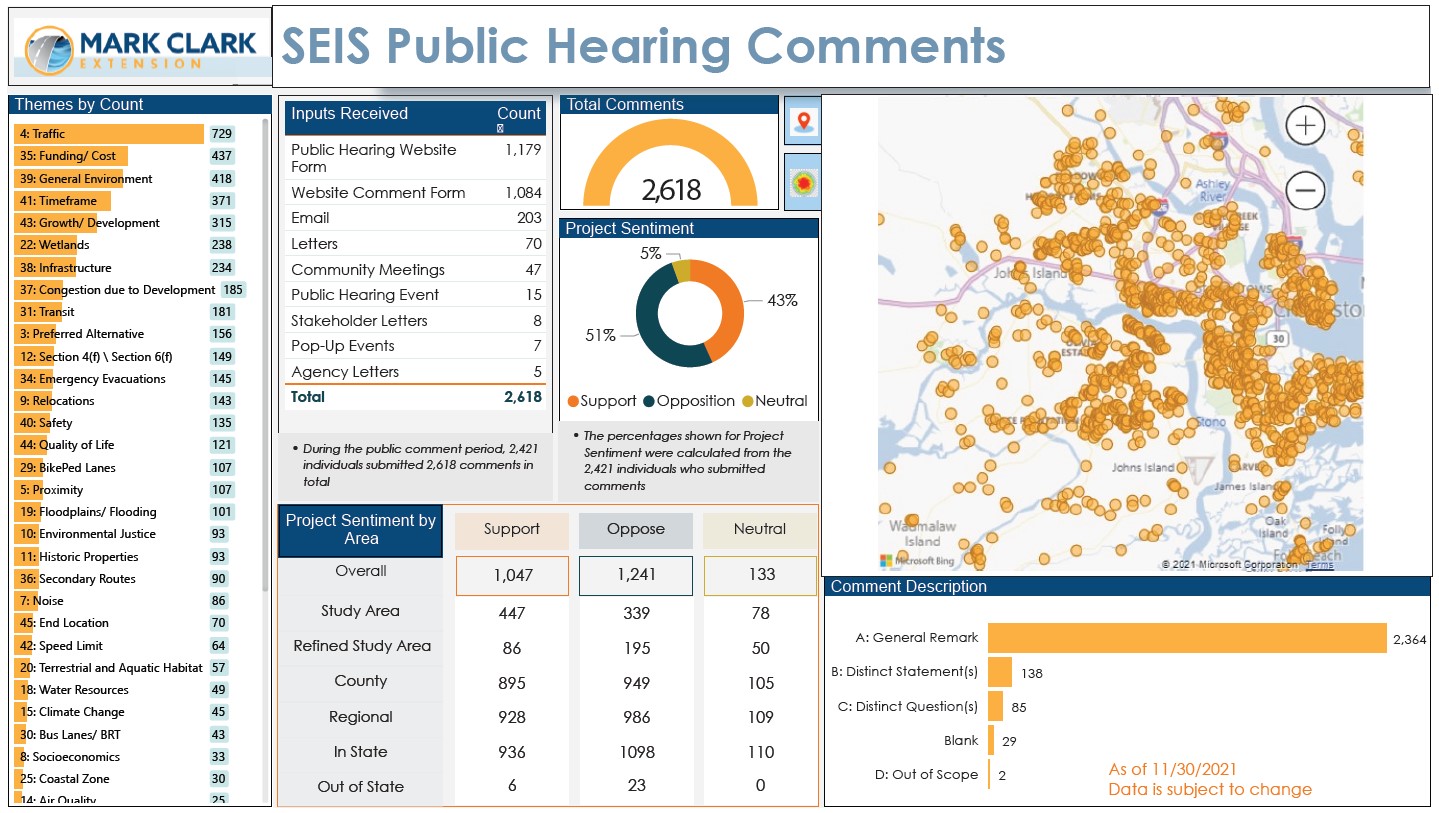
What did we hear during the 2021 Public Hearing comment period?
Below is a summary of the number and type of comments received during the 2021 SEIS Public Hearing comment period (August 18 to October 15, 2021).
Document Archive
2010 Draft Environmental Impact Statement (DEIS) Documents
+ 2010 DEIS Documents
+ 2010 Public Hearings (Maps & Displays)
The South Carolina Department of Transportation (SCDOT), Federal Highway Administration (FHWA), Charleston County, the US Army Corps of Engineers, and South Carolina Department of Health and Environmental Control - Ocean & Coastal Resource Management (SCDHEC-OCRM) held five public hearings for the public to offer input on the Mark Clark Expressway Draft Environmental Impact Statement (DEIS) and the SCDOT Recommended Preferred Alternative.
After officially releasing the Mark Clark Expressway DEIS and the SCDOT Recommended Preferred Alternative on July 28, 2010, some concern was expressed that having two public hearings at one central location could limit the ability to reach all the people who may want to share their thoughts and comments. Three additional meetings were scheduled for September 7, 8, and 9 at West Ashley High School, James Island Charter High School, and St. Johns High School, respectively.
Each public hearing followed the same format: an open house question and answer opportunity starting at 5 pm and a formal presentation and comment period, starting at 6 pm. All comments received at the meetings and during the comment period will be incorporated into the official record. The two-month public comment period on the DEIS and Recommended Preferred Alternative ended on September 30, 2010.
All comments received were included in the official record and those with addresses received a written response. Input gathered during the public comment period was incorporated with additional field studies to refine the project’s final design and mitigation measures. The Mark Clark Expressway Final EIS and Record of Decision had an anticipated completion date of spring 2011.
Meetings held: Tuesday, August 31, 2010 & Thursday, September 2, 2010: Burke High School; Tuesday, September 7, 2010: West Ashley High School; Wednesday, September 8, 2010: James Island Charter High School; Thursday, September 9, 2010: St. John's High School
+ 2008 Public Information Meetings
2008 Public Information Meeting (Fall)
Three open-house Public Information Meetings were held in the project area from 5:00 PM to 7:00 PM. The meetings were held at Fort Johnson Middle School on November 12, 2008; West Ashley High School on November 18, 2008; and St. Johns High School on November 20, 2008.
The purpose of the meetings was to present updated project information and to collect input and comments on:
- Draft of the Project Purpose and Need;
- Range of Alternatives Presented; and,
- Additional Alternatives that may need to be considered.
The public was encouraged to attend the meetings to provide comments and input into this project.
2008 Public Information Meeting (Spring)
A Public Scoping Meeting was held on April 10, 2008 from 6:00 PM to 8:00 PM. This open-house meeting was held at Murray-LaSaine Elementary School at 691 Riverland Drive (James Island). The purpose of this meeting was to:
- Introduce the project to the public;
- Gather initial comments from the public;
- Identify the needs for the project;
- Identify concerns the public may have about the project or its impact to the human and natural environment; and,
- The public was encouraged to attend in order to meet the project team and provide input into this important project.
In addition to mailing a postcard invitation to residents within five zip codes located in the study area, notification of the Public Scoping Meeting was published in project area newspapers: The Post and Courier (March 28, 2008); The James Island Journal (April 3, 2008); The Charleston Chronicle (April 2, 2008); and Island Life News Magazine (insert placed in the March/April 2008 edition on April 1, 2008).
+ 2008 Notice of Intent
Following the project initiation, a Notice of Intent (NOI) to prepare an Environmental Impact Statement, as required by CEQ regulations 40 CFR 1501.7 was prepared. The NOI was published in the Federal Register on January 9, 2008.
+ 2010 DEIS Project Newsletters and Updates
2013 Update (Spring)
The proposed project has been under careful consideration since the publication of the DEIS and the public hearings. Most recently, by Charleston County action per a resolution dated December 13, 2012, efforts associated with evaluation of the proposed Mark Clark Expressway are moving forward again. Charleston County has specifically approved advancing Alternative G through the Final EIS and Record of Decision, with the following modifications:
- A grade-separated interchange at Folly Road, including an overpass at Up on the Hill Road on James Island
- An overpass to maintain the connectivity of East Shore Lane in West Ashley
- A speed limit of 45 miles per hour
In addition to these design modifications, Charleston County has requested that efforts be made to eliminate traffic signals along the route and provide an overpass at Riley Road on James Island.
Detailed evaluations of traffic impacts, potential environmental impacts, engineering analyses, and the modifications listed above will be evaluated through the development of the Final EIS. It is anticipated that the Final EIS will be complete and a Record of Decision will be made by the Federal Highway Administration in approximately 12 to 18 months.
2011 Update (Summer)
Upon the signing and release of the Draft Environmental Impact Statement (DEIS) in August 2010, the project team held five (5) public hearings to announce the Recommended Preferred Alternative and collect input on the project from the public and stakeholders. During the subsequent public comment period 2,170 comments were received from 1,657 individuals.
Since then, Charleston County has been working with SCDOT, FHWA, and other project stakeholders as they carefully consider the most appropriate path forward for the Mark Clark Expressway project. Once a decision on the path forward has been identified, the project team will respond to all public hearing comments and provide further updates to the community.
Thank you for your interest and participation in the project.
2010 Update (Summer)
As of Monday, July 26, 2010, the South Carolina Department of Transportation (SCDOT) and Federal Highway Administration (FHWA) have signed the Draft Environmental Impact Statement (DEIS) for the Proposed Extension of the Mark Clark Expressway. SCDOT and Charleston County will hold a media release to announce SCDOT’s Recommended Preferred Alternative on Wednesday July, 28, 2010 at 10:00 in Charleston County Council Chambers.
Mark Clark Expressway Project Update Newsletters will be mailed to residents this week, also announcing the Recommended Preferred Alternative and that Public Hearings have been scheduled for August 31 and September 2 at Burke High School.
Check back for more project updates and information as it becomes available.
2009 Update (Spring)
The last series of public meetings for the proposed Mark Clark Expressway project was held in April and May of 2009. SCDOT had initially planned to announce the Recommended Preferred Alternative by the end of 2009. Although the project has been steadily moving forward with environmental studies since that time, the project team would like to keep you informed of the progress that has been made since our last update.
Since the last series of public meetings and the Summer 2009 newsletter, the Mark Clark Expressway study team has been busy evaluating the reasonable alternatives that were presented to the public for the development of the Draft Environmental Impact Statement (DEIS). Through the development of the DEIS, alternatives have been refined, evaluated, and eliminated based on how well they addressed the need and purpose of the project and the potential impact they would have on the social, economic, and natural environment. The study team has also refined each of the reasonable alternatives in response to public comments and in order to minimize potential impacts, where possible. In addition, the study team has continued evaluation of the Mass Transit and Transportation Systems Management alternatives as introduced to the public at the meetings held in April and May 2009.
A description and location map of each new construction reasonable alternative is provided below:
Alternative A (a revised version of former Alternative 1) Alternative A extends from the existing interchange at Mark Clark Expressway/U.S. 17, across the Stono River, to intersect Maybank Highway on Johns Island. The alignment then traverses James Island south of James Island County Park to end at the existing James Island Connector/Folly Road interchange. This is a fully controlled access facility. As a result of the input from the agencies, project stakeholders and the public, various adjustments were suggested to be made to the alignments. One mile south of U.S. 17, Alternative A was shifted east of its original position after passing over South Shore Drive in the Oakland neighborhoods to avoid impacting the community dock that serves the Battery Haig subdivision.
Alternative B (a revised version of former Alternative 8) Alternative B extends from the existing interchange at Mark Clark Expressway/U.S. 17, across the Stono River. On Johns Island, this alignment avoids the intersection of Maybank Highway and River Road by providing an interchange on Maybank Highway west of this intersection. The alignment traverses the Stono River and James Island, south of the James Island County Park, to end at the existing James Island Connector/Folly Road interchange. This is a fully controlled access facility.
As a result of the input from the agencies, project stakeholders and the public, various adjustments were suggested to be made to the alignments. One mile south of U.S. 17, Alternative B was shifted east of its original position after passing over South Shore Drive in the Oakland neighborhoods to avoid impacting the community dock that serves the Battery Haig subdivision.
Alternative C (a revised version of former Alternative 10) Alternative C extends from the existing interchange at Mark Clark Expressway/U.S. 17, across the Stono River, to intersect Maybank Highway on Johns Island. It then crosses James Island, north of James Island County Park near Ferris and Cyrus Road and connects to the existing James Island Connector/Folly Road interchange. This is a fully controlled access facility.
As a result of the input from the agencies, project stakeholders and the public, various adjustments were suggested to be made to the alignments. One mile south of U.S. 17, Alternative C was shifted east of its original position after passing over South Shore Drive in the Oakland neighborhoods to avoid impacting the community dock that serves the Battery Haig subdivision.
Alternative D (a revised version of former Alternative 11) Alternative D extends from the existing interchange at Mark Clark Expressway/U.S. 17 to Johns Island where two spur interchanges are located. These spurs would be partial interchanges at River Road north of Maybank Highway (Spur A) and River Road south of Maybank Highway (Spur B). The alignment then traverses James Island ending at the existing James Island Connector /Folly Road interchange. This is a fully controlled access facility.
As a result of the input from the agencies, project stakeholders and the public, various adjustments were suggested to be made to the alignments. One mile south of U.S. 17, Alternative D was shifted east of its original position after passing over South Shore Drive in the Oakland neighborhoods to avoid impacting the community dock that serves the Battery Haig subdivision.
Alternative E (a revised version of former Alternative 11A) Alternative E extends from the existing interchange at Mark Clark Expressway/U.S. 17 to Johns Island and provides one spur interchange, Spur 11A. (This alternative is the same as Alternative 11, but Spur B has been removed.) This spur would be a partial interchange at River Road, north of Maybank Highway and would provide a connection to Maybank Highway near Sailfish Drive. The alignment then traverses James Island ending at the existing James Island Connector/Folly Road interchange. This is a fully controlled access facility.
As a result of the input from the agencies, project stakeholders and the public, various adjustments were suggested to be made to the alignments. One mile south of U.S. 17, Alternative E was shifted east of its original position after passing over South Shore Drive in the Oakland neighborhoods to avoid impacting the community dock that serves the Battery Haig subdivision.
Alternative F (a revised version of former Alternative 36) Alternative F extends from U.S. 17 across the Stono River to Johns Island but it is proposed as a four-lane parkway with low speeds. On Johns Island, this alternative provides two connector roads. These access points would be located at River Road north of Maybank Highway and River Road south of Maybank Highway. On James Island, the parkway would utilize Central Park Road, which would be widened to four lanes with a raised median to the James Island Connector. Access to the parkway would be provided at intersections with Maybank Highway, Folly Road, and other future connections.
As a result of the input from the agencies, project stakeholders and the public, various adjustments were suggested to be made to the alignments. One mile south of U.S. 17, Alternative F was shifted east of its original position after passing over South Shore Drive in the Oakland neighborhoods to avoid impacting the community dock that serves the Battery Haig subdivision. Additionally, Alternative F was shifted north of its original position on James Island, west of Riverland Drive to avoid impacting Murray-LaSaine Elementary School, which is eligible for the National Register of Historic Places.
Alternative G (a hybrid version of former alternatives 11 and 36)Alternative G Traffic MapAlternative G is a new hybrid alternative that was added to the range of reasonable alternatives in response to public comments made at the series of public meetings held in April and May 2009. Public comments showed support for the parkway design and the inclusion of bicycle and pedestrian facilities; but comments also expressed concerns about the potential impacts along Central Park Road associated with Alternative 36. In response to these comments, the study team looked at the possibility of alternate routes for a parkway on James Island. The study team merged the alignment of Alternative D (formerly Alternative 11) and the parkway design of Alternative F (formerly Alternative 36) into a hybrid alternative, Alternative G.
Alternative G extends from U.S. 17 across the Stono River to Johns Island as a four-lane parkway facility with low speeds (i.e. 35 to 45 mph). This alternative provides two connector roads onto Johns Island. These connector roads would tie into River Road north of Maybank Highway and River Road south of Maybank Highway. On James Island, the parkway would pass through the northern edge of the James Island County Park. After passing Riverland Drive, Alternative G continues northeast, south of the Regatta Apartments, Carmike James Island Cinema and the U.S. Post Office, tying into the existing James Island Connector/Folly Road interchange. Alternative G provides access to Central Park Road via Riley Road and Up on the Hill Road. This alternative provides a multi-use path to accommodate bicycle and pedestrians.
Within the James Island County Park, a minor shift in the alignment moved the parkway closer to the northern boundary of the park to minimize disruptions to park facilities. Alternative G would provide connections to existing streets on James Island and would include a multi-use path along one side for its entire length to accommodate bikes and pedestrians.
2009 Update (Summer)
Currently, SCDOT is in the process of finalizing the DEIS document and submitting it for review. The completed DEIS will provide a summary of the entire project development process, including public involvement, the evaluation of the impacts associated with each of the reasonable alternatives, and SCDOT’s Recommended Preferred Alternative.
The DEIS will be released once the document is finalized and signed by the Federal Highway Administration (FHWA) and SCDOT. Following the release of the DEIS, two public hearings will be held to provide the public with another opportunity to review the project and provide comments. The public hearing will include an informal, open-house format session, similar to past meetings. This session will provide displays with project information for the public to review and ask questions of project team members. A formal session will also take place with a presentation on the project and public comment period. Public hearing dates and locations will be announced on this website and throughout the community. These two public hearings will follow identical format and will present identical content, allowing the choice of days to attend. The public is encouraged to attend either of these two hearings. It is anticipated that the DEIS will be finalized and released to the public in Summer 2010.
Following compilation of the public hearing transcript and comments made by the public and resource and regulatory agencies on the DEIS, SCDOT will begin putting together the Final Environmental Impact Statement (FEIS).
+ 2016 Mark Clark Expressway Extension Reevaluation
File Archive